| Ojos
del Salado Expedition The team Schedule(*) December 21st : The whole team gathers in Santiago to ultimate details prior to departure. We get suplies and transport (4WD truck) in Santigo. December 22nd : We leave Santiago for Copiapo. December 23rd: - Arrival in Copiapó. We get more suplies. Get in contact with the "Intendencia Regional de Atacama" to get climbing permit from this institution: bring the DIFROL authorization to Mrs. Nelly Lopez [calle Los Carrera Nº 645, piso 2º, Copiapó; teléfono (56 52) 212 727, fax (56 52) 212 859]. December 24th: - Extra day in Copiapó: We get last suplies and prepare for beginning of approximation. December 25th: - We leave for Vallecito (3100 m, 120 km from Copiapó [2 hr ride]). There we set up camp 1 and we do a short trekking of 1 hr. Dinner at 20:00 hr.
December
30th: - Breakfast at 08:30. At
11:00
hr we move on to "Refugio Atacama" (5.260 m).
Climbers must walk from 5.000
m up to the shelter (2 hr). The hike goes by the vehicle track
(sandy and rocky terrain, 15º). The equipment goes in the
vehicles. Lunch at 14:30 hr at the shelter. Resting in the afternoon.
Dinner
at 20:00 hr. In this place, night temperatures may
go from -10ºC, to -15ºC.
December
31st: - Breakfast
at 08:30 hr. We carry food and equipment to "Refugio Tejos" (5.837
m). This hike takes 3 hours by a vehicles track of 20º
to 30º with
sand. Each member of the expedition have to carry at least 1 Kg of
common equipment. In "Refugio
Tejos" we will rest for about 30 min. We go back to
"Refugio Atacama" to have lunch. This
walk takes 1 hr. After lunch we rest. Dinner at 20:00
hr.
January
1st: - Breakfast
at 8:00 hr. We bring all our equipment to
sleep at "Refugio Tejos".
Each climber must carry all his/her warmest equipment. Lunch at 12:00 hr. Free afternoon. Dinner at 19:00
hr and sleeping in "Refugio Tejos" (or nearby if occupied) at 20:30
hr.
January
2nd: - Breakfast at 4:00
AM. FIRST SUMMIT ATTEMPT (walking up to the summit
should take about 8
hr or less). Very low temperatures (from -25ºC to
-30º C) and strong winds above 80 Km/hr are expected. We need
crampons to go
accross a glacier
of 35º and 100 m long at 6.550
m,
sticks or ice axe, and at least 1 liter of water. This climbing
is
made over a very clear and sandy track of 15º to 40º. After a
6 hour
walk we should get to the crater of the volcano, from there we will
walk by big rocks up to the feet of the last climb. From there and up
to
the summit we will climb up through 30 m (at 6.860 m) of rocks
(5.6 degrees in the YDS).
Rope assistance for
glacier crossing and last rock climb may be required. On the very
summit may
stay up to 6
climbers.
January
4th: -
Breakfast at 09:00 hr. We begin our return to
Copiapó at 11:00 hr. At 13:00 hr we get some
food on the way to arrive in Copiapó
at about 17:00 hr.
January
5th: - We leave for Santiago.
January
6th: - Back in Santiago.
Summary of the route Santiago - Elevation: 567 m.a.s.l Copiapo - Elevation: 291 m.a.s.l Vallecito - Elevation: 3100 m.a.s.l / Camp 1 Laguna Santa Rosa - Elevation: 3780 m.a.s.l / Camp 2 Co. Siete Hermanos - Elevation: 4780 m.a.s.l Maricunga - Elevation: Elevation: 3700 m.a.s.l / Custom office, documents check point Laguna Verde - Elevation: 4340 m.a.s.l / Camp 3 Co. Mulas Muertas - Elevation: climb only up to 5000 m.a.s.l Refugio Atacama - Elevation: 5260 m.a.s.l / Camp 4 Refugio Tejos - Elevation: 5837 m.a.s.l / Camp 5 Ojos del Salado - Elevation: 6887 m.a.s.l Maps: From Google Maps: http://maps.google.com/maps?ll=-27.109660,-68.542230&spn=0.886064,1.330719&t=k&hl=en http://maps.google.com/maps?ll=-27.109660,-68.542230&spn=0.443035,0.665359&t=k&hl=en http://maps.google.com/maps?ll=-27.109660,-68.542230&spn=0.221517,0.332680&t=k&hl=en http://maps.google.com/maps?ll=-27.109660,-68.542230&spn=0.110759,0.166340&t=k&hl=en From Aventurismo.cl: 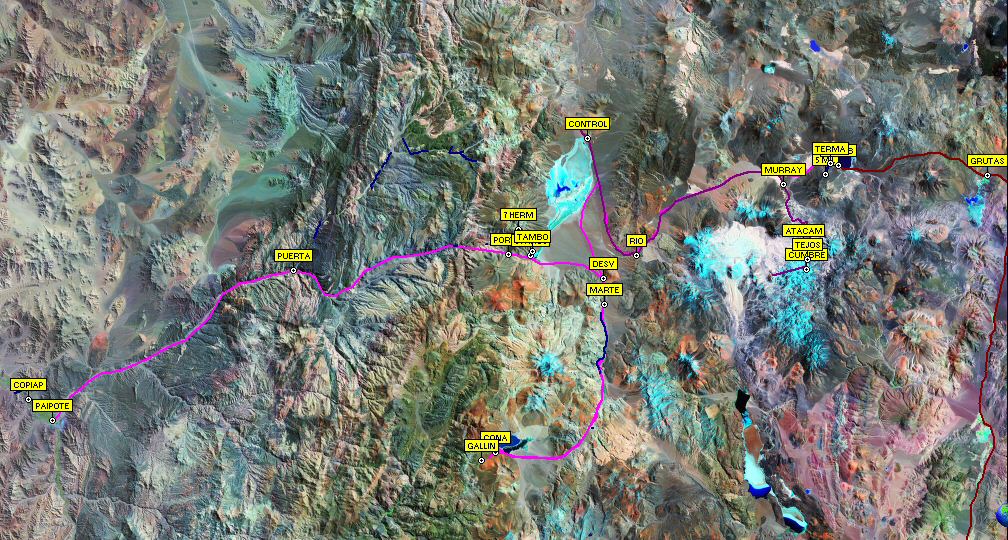 From Turistel: 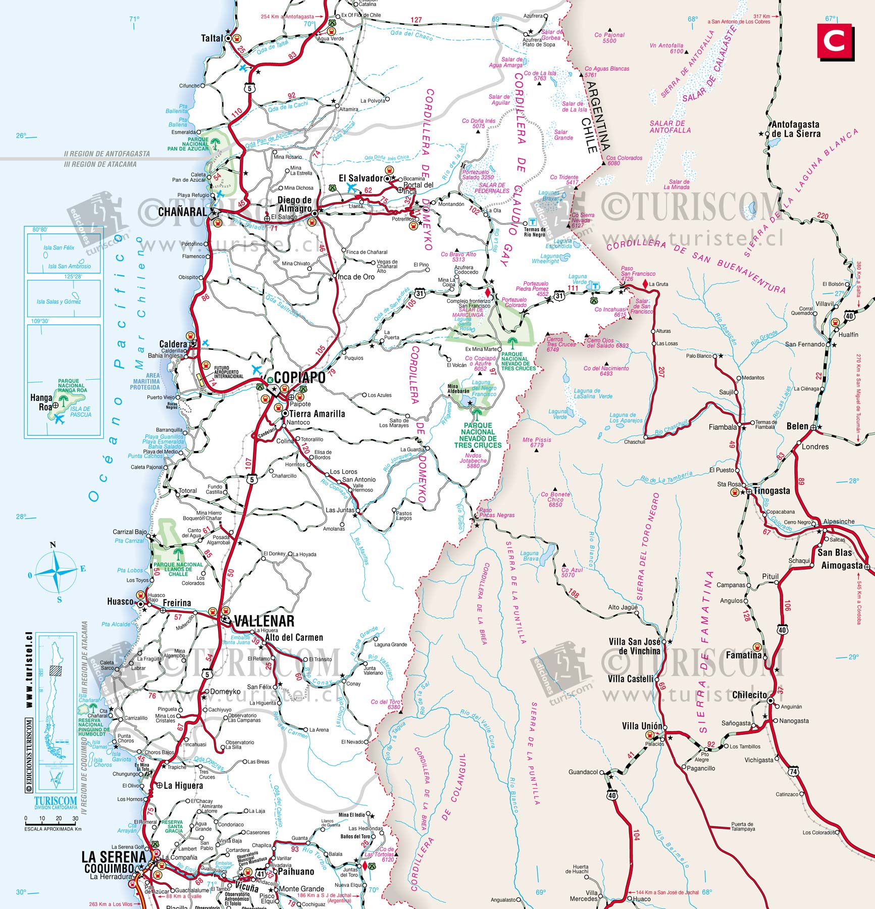 (*)
Adapted
from http://www.aventurismo.cl/articles.php?lng=en&pg=2
| Back to main page | R. Demarco - Last update: 10 November 2005 |